


While it may be Canada’s smallest province by land mass and population, Prince Edward Island has always been larger than life – it’s more about quality over quantity. When it comes to magnificent views, incredible adventures and life-changing experiences, the gentle island still has no equal.
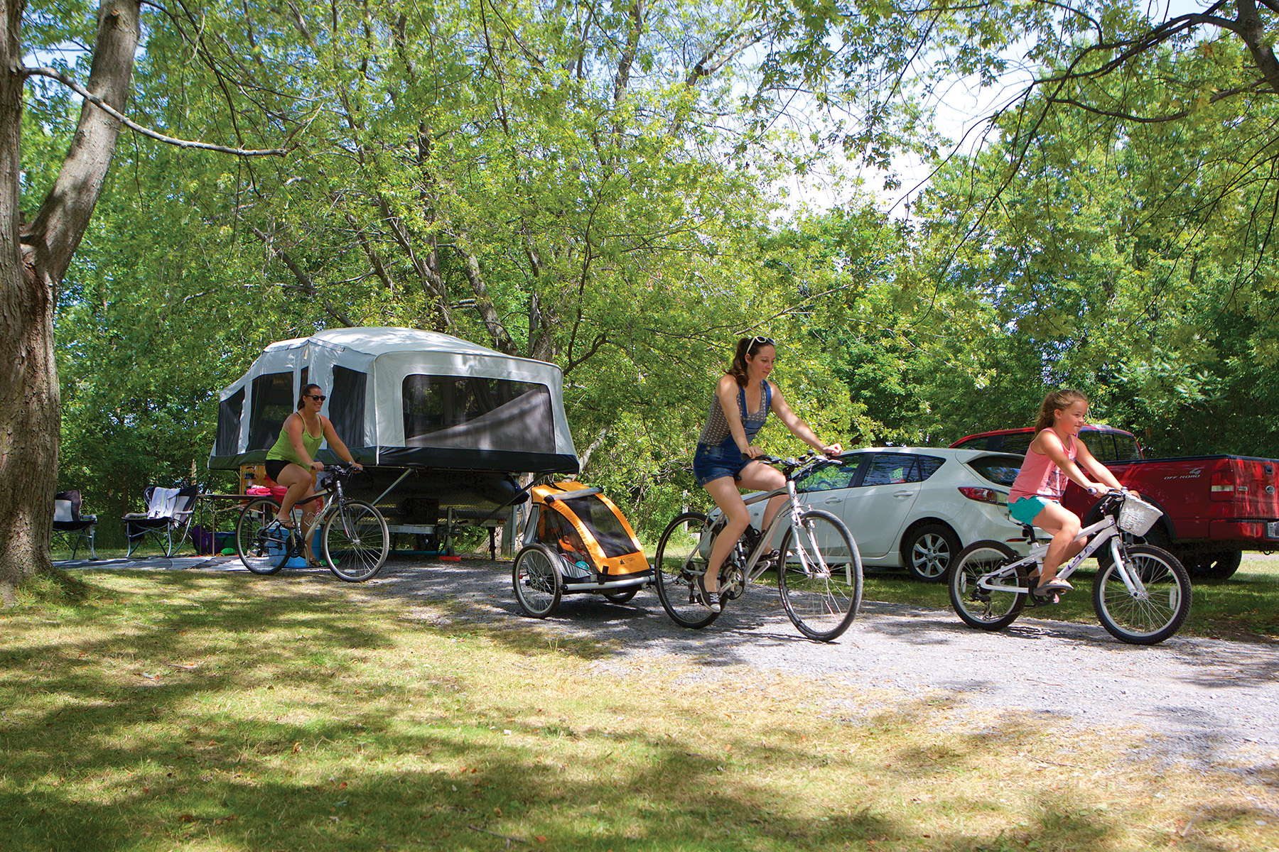
Although getting there is easy, the toughest part about any visit to PEI is deciding where to start. Prince Edward Island is divided into three counties – Prince, at the western end, Queens in the middle, and Kings, to the east. To really appreciate the Island’s charm, you need to spend a bit of time in each county, for they’re all just a bit different. Having an RV allows you to circumnavigate the island and really see it all, whether you arrive at Borden-Carleton via the Confederation bridge or, as I prefer, at Woods Island via the ferry. While the bridge is quick and convenient, the ferry is perhaps a bit more dramatic – especially as you watch the island loom larger on the horizon, and begin to anticipate all that awaits.
The continent of North America spans the Northern Hemisphere from the chill of the Arctic Ocean, to the tepid waters of the Gulf of Mexico. On the west is the endless Pacific Ocean, matched east coast by the smaller Atlantic Ocean. In spite of its massive presence, this land was populated by small tribes of indigenous peoples, but remained unexplored by the rest of the world for millenia.
Around the 10th century AD, Viking explorers sailed the eastern waters of the continent, leaving few traces behind other than the important site exposed at L’Anse aux Meadows in northern Newfoundland. These travellers would have been the first European explorers and settlers of the North American continent. Columbus was behind the times arriving in North America in 1492.
Not long after the voyages of Columbus, the government of France sent Jacques Cartier to search for riches in the New World. There also was great interest in finding a water route to the far east through this barrier of forest and rock, and explorers also sought a route to Asia that was frequently referred to as the North West Passage.
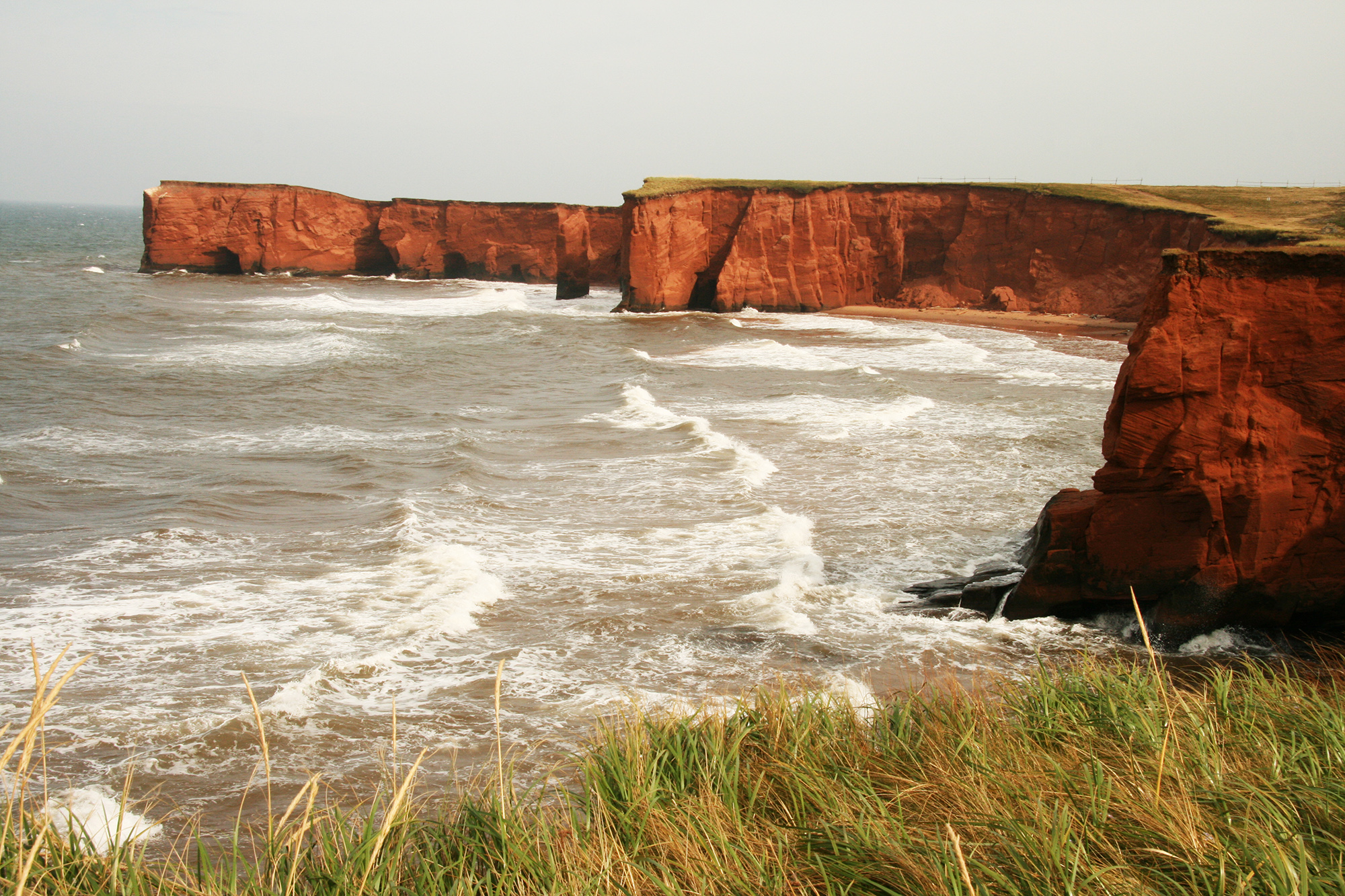
As Cartier sailed south along the north shore of the Gulf of St. Lawrence, he discovered a mighty river system that reached into the heart of the continent. In the summer of 1534 he discovered the Magdalene Islands, a group of islands far out in the Gulf. Today, these islands are a wonderful RV destination. Abundant sand dunes, fantastic choices of sea food, and lots of beach fun await you. Cartier later anchored in a long bay which was unusually warm. They named it the Bay of Chaleur. While there, he established a fur trade with the local tribes. Farther along the coast, at Gaspé, he did some trading and erected a large wooden cross. Realizing the vast potential of the fur and timber trade, he claimed the entire Gaspé Peninsula for France. In 1934 the town of Gaspé erected a large stone cross celebrating 400 years since Cartier staked his claim for France.
A highway trip around the Gaspé Highway in Quebec is a favourite drive for many Canadians. Much of the country remains as Cartier found it – rugged and beautiful, with the blue ocean leaving streaks of white foam on the cliffs.
In 1535, Cartier proceeded up the river to the present day site of Montreal and later carried home word of rich soil and forests to the King of France, along with a false dream of hidden treasures nearby.
A few years later, in 1608, the French explorer Samuel de Champlain established Quebec City. He worked under difficult conditions to be sure that the settlement could exist on a self-sustaining basis. Things didn’t turn out well at first, but the resulting Quebec City is a destination for thousands of visitors each year.
Over the years, Champlain continued exploring the Great Lakes region, establishing a collection of fur trading centres, and he realized that this fresh-water source was rich in fish, but it did not hold the key to the North West Passage – the river flowed in the wrong direction! Some of voyages of exploration include following the Ottawa River north and branching over to Lake Huron. He went west through what is now Ontario, to the Peterborough area, exploring the land and visiting with the natives along the way.
As the fur trade became more important to the economy of the little settlement at Quebec, the St. Lawrence River increased in importance as the main highway for commerce in North America. In 1680, the Lachine Rapids at Montreal were bypassed by digging a canal across the island. In 1780 a 7-lock canal was constructed joining the Old Port of Montreal to Lake St. Louis on the west. In 1824 the British rebuilt the Lachine Canal using only 5 locks.
Since 1977, tourists can walk or bike the 14.5 km scenic route along the Lachine Canal. You can be in downtown Montreal, and still be in the midst of a lot of green space. At the Atwater Market Dock you can visit the Canal Lounge Floating Café after 5pm. You can also ride to the ‘The Fur Trade at Lachine’ National Historic Park on the shore of Lake St. Louis.
In the early 1780’s the British built 4 canals to carry boats from Lake St. Louis to Lake St. Francis a little farther upstream to the west. If you can imagine these canals, they were only three-quarters of a metre deep and capable of taking a huge boat, providing it was no more than 2 metres wide. It doesn’t sound like much, but these canals provided an essential link in the trade route to move a wide range of goods and commodities.
Eventually, a canal and locks was built to bypass the rapids at Long Sault. There are old pictures showing ships running the rapids – this was a risky business, as the deeper channel did not allow very much room for error.
In the mid 1900’s, Canada started to get serious about creating a canal that could carry large ocean ships up the 67 metres climb to Lake Ontario. Negotiations with the US were going nowhere, so Canada decided to build the new project, the St. Lawrence Seaway, alone, on the Canadian side of the river. It wasn’t long before the US became a partner in the Seaway project, but Canada paid 71.5% of the costs.
The St. Lawrence Seaway project had to surmount several difficulties. The planners wanted to avoid the Lachine canal by staying on the south side of the river to miss congestion at Montreal. This required either jacking up, or modifying four major bridges across the river, without stopping traffic, to provide 36 metres of clearance for ships. The Jacques Cartier Bridge had to rise 15 metres while still keeping the traffic flowing during the lift phase.
In order to smooth out the Long Sault Rapids, engineers decided to dam the river and create a monster lake. Two locks, the Eisenhower, and Snell, would lift the up bound ships into the new lake. Here at the Eisenhower Lock you can have the unusual treat of watching a ship sail across the road while cars follow a tunnel under the canal. The Saunders Dam would produce power for Canada and the US, shared equally.
This engineering marvel created a whole list of challenges. The reservoir created by the dam would drown the farms and villages of over 6,500 people who lived in the area. Big float trucks carried homes and churches to new locations. Even cemeteries found new homes. Still, several towns disappeared under the swirling waters. A pleasant bonus from the flooding was the formation of the Long Sault Parkway, a road built in a park atmosphere, linking the tops of islands, former hills, to the shore. It is a nice drive, although short, and the several picnic areas and campgrounds along this twisting route provide lots of chance to relax. If you like to fish, the river is right there!
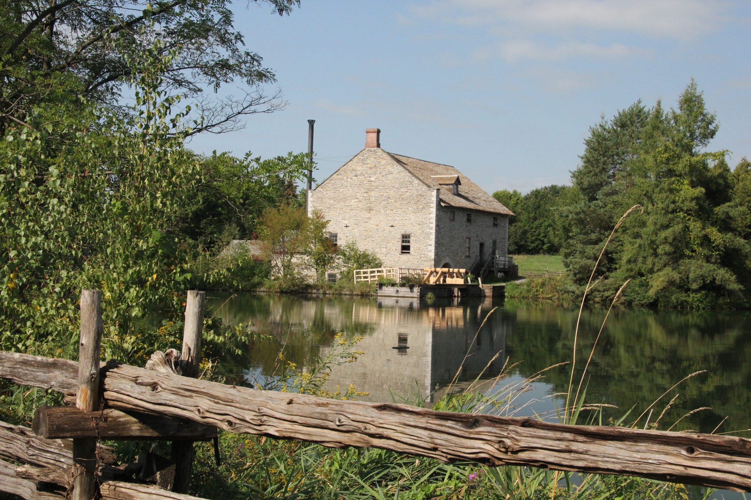
Along the river, you will find the Upper Canada Village Heritage Park. This is a living village of the mid 1800’s, showing life similar to that in the vanished villages. Pass through the entrance doors and life slows down, not to a crawl, but to a more relaxed way of living. How nice it is walking along the streets edged in big trees. A central grassy field is used for agricultural fairs and other similar events. The village church is visible from almost everywhere. A working woolen mill built by a pond rumbles away, cleaning the wool, twisting the thin hairs into yarn, and creating cloth as you watch.
Across the pond, are big piles of fresh smelling lumber. Inside the wooden building, the dammed water passes through a simple waterwheel to run a vertical saw that looks very slow and cumbersome, yet the stacks of lumber indicate that this is not the case. Using only a meagre 5-horsepower, the saw can cut through a one metre diameter oak, 5 metres long, in only 7 minutes. Anyone who is old enough to have used a cross-cut saw to cut down trees or saw blocks off the trunk of a tree, will appreciate the difficulty involved in sawing lumber this way. However, this antique saw was a great step forward from the days when there was one man above the log, and one man below in a pit, who used a saw, similar to a cross-cut, and sawed the lumber off the log. I wonder how they decided which one worked down below in the shower of sawdust?
The Thousand Islands region is one of the most scenic portions of the St. Lawrence River. It is interesting to note that the river has several hundred more islands than the reputed 1000… you could easily get lost boating through some of the smaller channels. Time after tome, this has proven to be historically significant. During the War of 1812, the channels provided safe passages for forces on both sides of the conflict. During the Prohibition era, the whisky runners found the myriad of islands and channels to be ideal – they needed places to hide when the law was after them. Those wise in the ways of the river could be slipping up one side of a group of islands while the law worked down the other.
Today, pleasure boats ranging in size from kayaks to huge yachts make the river their summer home. And why not? It is always exciting to watch the sparkling blue waters ripple past granite islands, some so small you wonder how that big pine tree keeps its precarious grasp on what looks like bare rock. You can listen to the leaves whispering to the winds as you slip down a narrow channel.
Many of the islands owe their presence to the Frontenac Axis, a fifty-mile wide tongue of granites and other igneous rocks that cross the river between Kingston and Brockville, connecting the Canadian Shield to the Adirondack Range. The great continental glacier carved the hard hills into the elongated streaks that would become islands when the ice retreated and the river began to flow.
If you have a few hours to spend cruising along the St. Lawrence River, Parkway Boat Line, located west of the Ivy Lea Bridge, provides tours that deliver a great opportunity for you to see the islands up close because their boat is small enough to navigate close to the shore.
 The staff at the nearby Ivy Lea KOA will give you information on the tour, and are keen to give you hints on what to see and do in the area. The campground, secluded in the forest, is just far enough off the highway to provide a quiet place to rest after a hard day on the water, or on the highway. Every summer, campers line the cliffs in this area to watch the Power Boating Canada 1000 Islands Poker Run – North America’s #1 event for performance boating enthusiasts. 100 of the most spectacular boats in North America challenge the waters of the mighty St. Lawrence River in this demonstration of the leading edge in performance boating technology, with some boats capable of travelling at speeds in the 200mph range.
Just west of the Ivy Lea Bridge, the city of Kingston commands the entrance to the river. On Fort Henry Hill, the old fort still points its cannons towards the open waters, waiting for the attack that never came. Pop in and spend a few hours prowling the thick stone walls and inner rooms. Visitors really enjoy the sunset ceremonies that are shown during the summer months where the troops perform field maneuvers complete with the roaring sounds of the guns mixed with the sounds of martial music.
North of Kingston, the horizon is very flat. This is part of the limestone plain, dissected in places with valleys and large lakes. Just a dozen miles to the north, out on the Historic Perth Road, is where the forested, rugged Canadian Shield creates a land of cliffs, and hundreds of lakes and streams. This is a populated wilderness, filled with cottages, homes, small farms, and abandoned lead, zinc, phosphate, and mica mins. Leading to the heart of the region, you can travel along the historic Sir John A. MacDonald’s toll road, which was built to open the country to the north of Kingston to easier settlement.
The St. Lawrence River was the early gateway to the continent, and in the modern era, the Seaway provides a busy route for commerce – without the early restrictions of the rapids and cliffs, large ocean ships can sail from the Atlantic waters to the far end of Lake Superior.
Today, the prospect of the St. Lawrence River as a major waterway for commerce and tourism continues to evolve, as thought is being given to increasing the size of the locks so that some of the largest ocean ships can continue to use this gateway to the heart of North America.
There is no better time to plan an RV trip to visit the many historical sites along this magnificent river system. Follow the routes of the voyageurs and the fur traders to discover the sites and scenes that have made Canada what it is today.
Eastern Ontario Attractions
The St. Lawrence Parks Commission operates a range of historic sites and recreational facilities along the shores of the St. Lawrence River. Attractions include: Upper Canada Village (Morrisburg), UNESCO World Designated Site Fort Henry (Kingston), Skywood Eco Adventure, Crysler Park Marina, Upper Canada Golf Course, 13 campgrounds and beaches, two parkways (1000 Islands Parkway, Long Sault Parkway) and the Upper Canada Migratory Bird Sanctuary.
For more information, please contact:
St. Lawrence Parks Commission 1-800-437-2233 or 613-543-4328 getaway@parks.on.ca
Or visit the website at http://www.parks.on.ca/
For more information, please visit:
http://www.uppercanadavillage.com/
http://www.tourismeilesdelamadeleine.com/en/
http://www.pc.gc.ca/lhn-nhs/qc/canallachine/index.aspx – about the Lachine Canal
http://www.quebecmaritime.ca/en/discover-our-regions/gaspesie – about Gaspé
RV Lifestyle Magazine’s Travel Editor, James Stoness, is the author of ‘Touring North America’, a series of travel guides on CD to help you plan your trips across North America, as well as a series of novels. Visit his website to read his novels and travel guides – https://stonessrvtravel.com/


